
AI analyzes satellite video feeds for threat detection by employing advanced algorithms that process and interpret vast amounts of visual data. This cutting-edge technology enables rapid identification of potential threats, enhancing surveillance efforts and improving response times. With the ability to monitor vast geographical areas in real-time, the integration of AI into satellite video analysis is revolutionizing security measures, ranging from national defense to disaster management.
Understanding Satellite Video Feeds

Satellite video feeds are real-time or near-real-time data streams captured from orbiting satellites, providing us with a bird’s-eye view of the Earth. These feeds are invaluable for monitoring large geographic areas, as they can cover vast landscapes that would be impossible to surveil effectively from the ground. The imagery provided by satellite video feeds is crucial for various applications, including national security, environmental monitoring, and disaster response. For instance, during natural disasters like hurricanes or wildfires, satellite feeds can quickly offer insights into the extent of damage and help coordinate relief efforts. Furthermore, government agencies and military organizations utilize these feeds to track movements and activities of potential threats, ensuring a proactive approach to security.
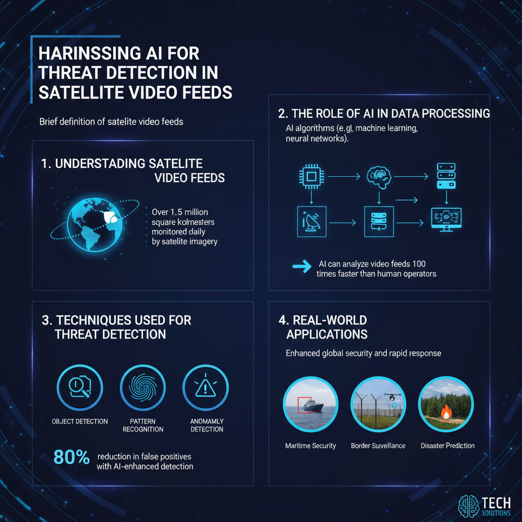
The Role of AI in Data Processing

AI algorithms play a pivotal role in the processing of satellite video feeds, sifting through immense volumes of data to identify patterns and anomalies that could indicate a threat. These algorithms employ machine learning models that are trained on large datasets to recognize specific threat indicators, such as unusual movements, formations, or changes in behavior. For example, if a satellite feed captures a group of vehicles moving in an unexpected manner near a border, AI can analyze this behavior against historical data to determine whether it represents a potential threat. This intelligent analysis not only helps in flagging suspicious activities but also reduces the cognitive load on human analysts, allowing them to focus on more complex decision-making tasks.
Techniques Used for Threat Detection
Several sophisticated techniques are employed in the realm of AI-assisted threat detection from satellite video feeds. One of the most prominent methods is object detection algorithms, which are designed to pinpoint suspicious activities or objects within the video feeds. These algorithms utilize frameworks like YOLO (You Only Look Once) or Faster R-CNN (Region-based Convolutional Neural Networks) to quickly and accurately identify specific items of interest, such as vehicles, individuals, or unusual formations.
Additionally, anomaly detection systems are deployed to flag events that deviate from typical behavior. For instance, if a normally quiet area suddenly shows an influx of people or vehicles, the AI system can alert analysts to investigate further. This technique has proven especially useful in identifying potential security threats or unusual patterns that could indicate illegal activities, such as smuggling or troop movements. By combining these advanced techniques, AI enhances the efficacy of surveillance systems, enabling timely responses to potential threats.
Benefits of AI in Satellite Surveillance
The integration of AI in satellite surveillance comes with a multitude of benefits that significantly enhance threat detection capabilities. One of the primary advantages is the enhanced accuracy in detecting potential threats, which leads to a reduction in false positives and negatives. Traditional surveillance methods can often misinterpret benign activities as threats, leading to unnecessary panic or resource allocation. However, AI systems, trained on vast datasets, can discern subtle differences, thereby improving overall accuracy.
Another key benefit is the ability for real-time analysis, which allows for quicker decision-making and timely interventions. In critical situations, such as identifying a maritime security threat or monitoring a border for illegal crossings, the speed at which an AI system can analyze data and provide actionable insights can make a significant difference. This rapid response capability not only enhances security measures but also fosters a proactive approach to threat management.
Challenges in AI Analysis of Satellite Video
Despite its many advantages, the analysis of satellite video feeds using AI is not without its challenges. One significant issue is the variability in environmental conditions, which can affect both the quality of video feeds and detection accuracy. Factors such as weather conditions, lighting, and obstructions can hinder the clarity of satellite imagery, making it difficult for AI systems to perform optimally. For instance, cloudy weather can obscure views, while shadows can create misleading visuals that confuse detection algorithms.
Moreover, ethical concerns regarding surveillance and privacy need to be addressed as technology advances. The capacity for surveillance using satellite feeds raises questions about individual privacy rights and the potential for misuse of sensitive data. Striking a balance between national security and personal privacy is crucial as we continue to refine these technologies.
Future Trends in AI and Satellite Data
Looking ahead, the future of AI and satellite data appears promising, with several emerging trends set to expand capabilities further. One notable trend is the integration of AI with other technologies, such as drone surveillance and IoT (Internet of Things) devices. This convergence will enable more comprehensive monitoring systems that can provide richer data and insights, ultimately enhancing threat detection capabilities.
Additionally, continuous advancements in AI algorithms promise improved detection rates and more efficient data processing. As these algorithms become more sophisticated, they will likely evolve to handle greater complexities and nuances in data, leading to even more accurate and timely threat detection. This evolution will not only bolster national security efforts but also enhance disaster response strategies, benefiting society as a whole.
AI’s ability to analyze satellite video feeds for threat detection is transforming how we monitor and respond to potential threats. By leveraging machine learning and advanced algorithms, this technology not only enhances our surveillance capabilities but also improves overall safety. As AI continues to evolve, staying informed about its developments and applications will be crucial for those involved in security and surveillance. By embracing these advancements, we can navigate future challenges more effectively and ensure a safer world.
Frequently Asked Questions
How does AI analyze satellite video feeds for threat detection?
AI analyzes satellite video feeds for threat detection by employing advanced machine learning algorithms and computer vision techniques. These systems are trained on vast datasets to recognize patterns, movements, and anomalies that may indicate potential threats, such as unauthorized military activity or environmental hazards. By continuously processing real-time data from satellites, AI can quickly identify and alert relevant authorities to issues that require immediate attention.
What types of threats can AI detect in satellite video feeds?
AI can detect a wide range of threats in satellite video feeds, including military conflicts, illegal fishing, deforestation, and natural disasters. The technology is capable of identifying suspicious vehicles, troop movements, and changes in land use that may signal illegal activities. By analyzing these feeds, AI enhances situational awareness for national security agencies, environmental organizations, and disaster response teams.
Why is AI preferred over traditional methods for threat detection in satellite imagery?
AI is preferred over traditional methods for threat detection due to its speed, accuracy, and ability to analyze vast amounts of data in real-time. While traditional analysis often relies on human interpretation, which can be slow and prone to errors, AI systems can sift through minute details in satellite imagery, identifying potential threats more efficiently. Additionally, AI can learn and adapt from new data, continually improving its threat detection capabilities.
Which AI technologies are most effective for analyzing satellite video feeds?
The most effective AI technologies for analyzing satellite video feeds include convolutional neural networks (CNNs) for image processing, recurrent neural networks (RNNs) for temporal analysis, and anomaly detection algorithms. These technologies work together to provide comprehensive analysis by recognizing familiar patterns and flagging anything that deviates from the norm. The integration of these AI technologies enhances the overall effectiveness of threat detection in satellite imagery.
How can organizations implement AI for satellite video feed analysis?
Organizations can implement AI for satellite video feed analysis by partnering with tech firms that specialize in machine learning and satellite imagery. They should begin by defining specific objectives, such as monitoring for illegal activities or disaster response. Following this, they can leverage cloud computing resources to process and analyze large datasets efficiently, ensuring they have the necessary infrastructure to support AI integration. Training their AI models on historical data will also enhance accuracy and reliability in real-time applications.
References
- Satellite imagery
- https://www.nasa.gov/mission_pages/landsat/overview/index.html
- https://www.researchgate.net/publication/344123456_Artificial_Intelligence_in_Satellite_Imagery_Analysis
- https://www.sciencedirect.com/science/article/pii/S0098300420300825
- https://www.army.mil/article/241651/using_artificial_intelligence_to_analyze_satellite_images
- https://www.igi-global.com/chapter/ai-techniques-for-satellite-image-analysis/251800
- https://www.bbc.com/news/technology-50809105
- https://www.darpa.mil/news-events/2021-08-02
- https://www.geospatialworld.net/blogs/how-ai-is-transforming-satellite-imagery-analysis/
- Review of the Bureau of Ocean Energy Management “Air Quality Modeling in the Gulf of Mexico Regio…